
Support The Crespogram

NUMBER 70 - MAY 1, 2019
WATER, WATER, EVERYWHERE: THE FUTURE OF MIAMI WILL ONE DAY RIVAL THAT OF THE OAKIES LEAVING OKLAHOMA DURING THE DUST BOWL YEARS

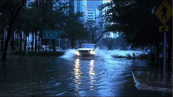
I have long maintained a dystopic view of the future of Miami as sea level rise continues unabated, in part because the geography of South Florida does not provide for the kind of options that other low-level cities around the world who are facing similar problems have, and more importantly because the politicians and business leaders in Miami are either grossly incompetent, politically incapable of rising to the requirements of providing real leadership, or in the case of developers, looking to make one last run at pouring concrete on every empty piece of land that they can before the party ends, and they cash out.
One only need to look at morons like Miami City Commissioner Joe "Comemierda" Carollo, and Boy Mayor Francis Suarez to realize that the City of Miami is doomed because no one in their right mind could ever place, or expect that their future was in good hands with politicians like these two at the helm.
There are people who are concerned, and who are trying to do something, but for the most part, they are not in the real positions of leadership where change can be tackled directly, or because of the way that the county is divided up into 34 separate municipalities.
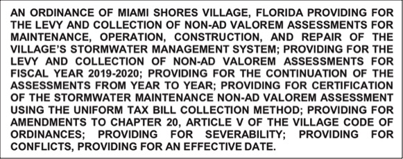
Last month, the Village Council of Miami Shores held a First Reading on an ordinance to assess a non ad valorem assessment to deal with sea level rise problems:

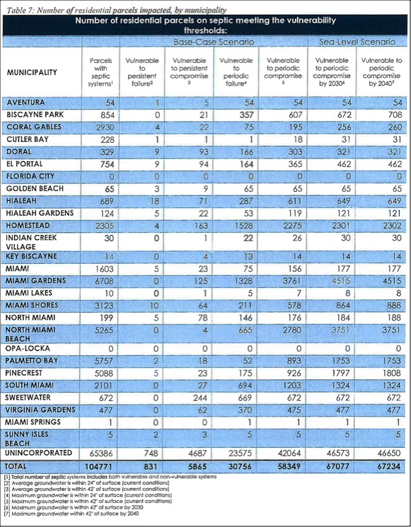
In the days following the revelation of this document by fellow resident Ronnie Guillin, I set out to try and find out the specific identity of the 864 and 888 Miami Shores residencies cited in the Table 7.
I would have fared better in setting out to get a copy of Donald Trump's tax returns.
I will forgo my inability to obtain what I initially assumed would be a document generated in advance of Table 7 being created that would have identified by location not only the residential properties in Miami Shores, but the location of all 67,234 residential properties in the county that have septic tanks, and have been identified in this document as being vulnerable to sea level rise.
In any event, after several phone calls and exchanges of emails, I did receive some helpful information for those who are concerned about their properties and what might lie ahead.
Below is a portion of an email with attachments that I received from Katherine Hagemann, who was involved in the preparation of the Septic Tank study, that explains some issues, and provides links to several helpful websites that can guide anyone in Miami-Dade County who is concerned about the effects of seal level rise on their property.
Katherine Hagemann's email:
"I would also reiterate the caveats we mentioned yesterday that the regional groundwater model is not accurate enough to identify whether specific parcels are or aren’t vulnerable. So residents should note that two parcels side by side may have different results in the model – even though they are very similar in reality. The model may show some parcels as at risk, when in fact they are not, and conversely some properties which do not show up as vulnerable in the modeling results are actually at risk based on the conditions on the ground. More detailed assessment is needed at the site scale to identify whether a property’s septic system is actually impacted. For our analysis we made uniform assumptions about the depths of systems, which will likely vary quite a bit in reality.To get a better picture of which properties could be affected by sea level rise there are a number of other resources that I would suggest. We have a number of technical reports on our website, if you’re looking for more background. There are also a number of user-friendly sites online:
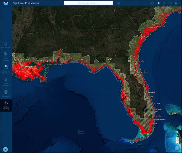
NOAA’s Sea Level Rise Viewer: this tool can give an overview of which areas are vulnerable to tidal flooding in the future. You can also see areas vulnerable to king tide flooding. (To visit site, click HERE.)
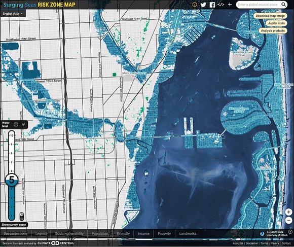
Climate Central’s Surging Sea’s Tool: this offers a number of layers you can compare future flooding to. They also generate a fact sheet on the impacts to different areas. I’ve included their report on the Miami Shores area as an attachment. (To view this program, click HERE.)
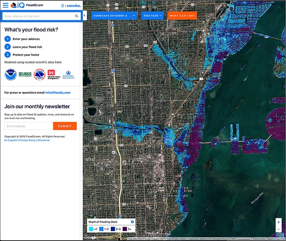
FloodIQ: this is a newer tool which allows you to look up a specific property’s address and include information on the vulnerability of flooding due to storm surge. Though with all models the results should be taken with a degree of caution as model results may be slightly different than the reality on the ground. (To view this program, click HERE.)
Vulnerability Septic Systems Sea Level Rise 1 by al_crespo on Scribd
Here is the Septic Systems Vulnerable To Sea Level Rise Report
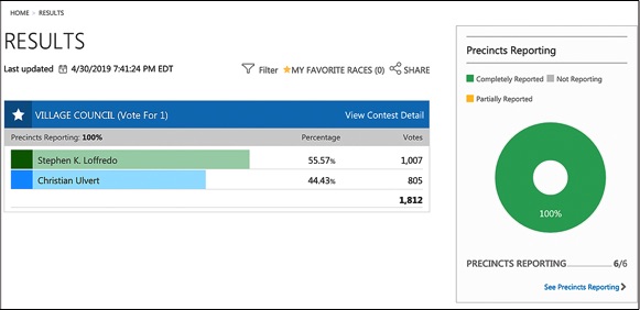
ULVERT LOSES, PROVING THAT SOMETIMES MONEY ISN'T ENOUGH TO OVERCOME A CANDIDATE WITH BAGGAGE WHO FOR A PRO, RAN A BAD CAMPAIGN
IN CELEBRATION OF THE MONTH OF MAY

The Village's efforts are stop gap at best, and when it comes to raising the sea wall along the portion of the Bay that is euphemistically called the Village's Bayfront Park, it's the equivalent of putting a bandaid on an arm severed by a machete.
The Village's bay front property is bordered on the south by the City of Miami, and to the north by Miami-Dade County and North Miami, and nothing of real consequence can be done to stop the surge of water from coming above, or below our little portion of seawall without their involvement and participation.
One issue that did come to light during the lead-up to the Council's First Reading was a copy of a report by the county on the vulnerability of the septic tanks in the Village as a result of seal level rise that included a table of the number of residential properties that might be affected by seal level rise.